
Hurricane Season Peaks in Atlantic as Storm Erin Looms Near US Coast
Hurricane Erin Batters Caribbean, Spurs US East Coast Flooding Warnings.
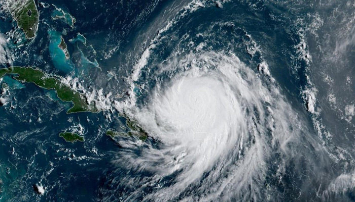
Hurricane Erin pounded parts of the Caribbean on Monday with heavy winds and rain, while triggering evacuations and flood alerts along the US East Coast despite no forecast landfall.
The storm, which briefly reached Category 5 strength in a record burst of intensification over the weekend, weakened to a Category 3 but remained “unusually large,” according to the US National Hurricane Center (NHC). Erin was carrying sustained winds of 125 mph (205 km/h) while moving northwest at 8 mph. Hurricane-force winds extended up to 80 miles from its center, with tropical-storm winds stretching 230 miles.
Rainfall of up to 4 inches (10 cm) was forecast for Cuba, the Dominican Republic, the Turks and Caicos, and the Bahamas. In Puerto Rico, flash flooding and power outages hit the island over the weekend, though most service has since been restored.
The NHC warned of life-threatening surf, rip currents, and coastal flooding from Tuesday through Thursday along much of the US East Coast, particularly the Outer Banks of North Carolina. Waves up to 20 feet (6 meters) could overtop dunes and flood homes and roads. Evacuations have already been ordered for Ocracoke and Hatteras islands.
Scientists say Erin’s rapid intensification was fueled by abnormally warm waters linked to human-driven climate change. “Hurricanes act like heat engines,” said Daniel Gilford of Climate Central. “Erin is one of the fastest-intensifying storms on record.”
The Atlantic hurricane season, running June to November, has now reached its peak. Despite a quiet start, US forecasters expect an above-normal season driven by record sea-surface temperatures and favorable monsoon conditions in West Africa.
Comments are closed.