

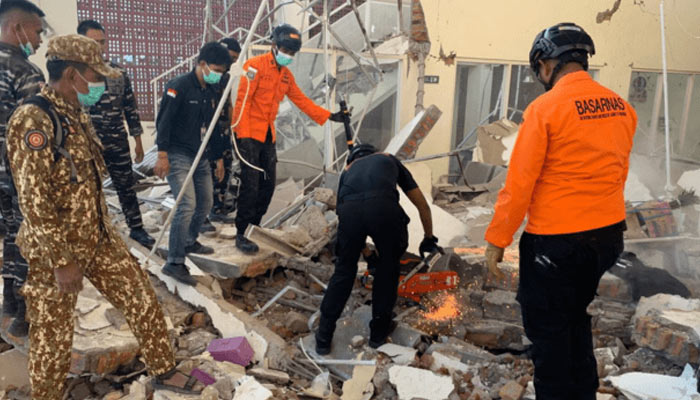
Indonesia’s Flores Jolted by 5.9 Magnitude Quake Days After Deadly 7.7 Tremor
Indonesia’s earthquake-hit Flores region was struck by a magnitude 5.9 earthquake on Monday, just days after a powerful 7.7-magnitude tremor devastated parts of East Nusa Tenggara. The earlier quake killed at least 53 people, injured more than 130 and caused extensive damage across the region.
The latest tremor was recorded by Germany’s GFZ Research Centre for Geosciences at a depth of around 10 kilometres. There were no immediate reports of fresh casualties or major damage.
The 7.7-magnitude earthquake struck East Nusa Tenggara on Saturday morning, with the US Geological Survey locating its epicentre around 68 kilometres northwest of Ende. The powerful tremor prompted a tsunami warning, sending residents in coastal areas to higher ground. The warning was later withdrawn after authorities found no significant changes in sea levels.
Death Toll Reaches 53
Indonesia’s National Disaster Management Agency said rescuers recovered 47 bodies on Saturday, primarily from Sikka, Manggarai and East Manggarai. Six additional bodies were recovered on Sunday, taking the death toll to 53.
More than 130 people were injured, while thousands of residents spent the night outside because of fears of further aftershocks.
Authorities initially recorded more than 230 aftershocks following the main earthquake. That figure later rose to at least 995, although only 46 were felt by residents. The strongest aftershock measured 6.2.
Hundreds of Homes Damaged
The earthquake destroyed more than 900 houses and damaged another 450 across East Nusa Tenggara. Around 5,000 people were forced to move into temporary shelters, while at least 241 homes were damaged in the Flores region.
More than 100 public facilities, including schools, healthcare centres and churches, were also damaged or destroyed.
East Nusa Tenggara police chief Rudi Darmoko said the earthquake caused extensive structural damage and building collapses, while power failures disrupted communication networks.
Landslides triggered by the quake also blocked parts of the Trans-Flores highway in Ende regency. The approximately 435-mile route connects Labuan Bajo with Larantuka and is a key transport link across Flores.
Remote Areas Cut Off
Rescue teams have warned that the death toll could increase as landslides have isolated or buried remote communities across six regencies. Indonesia’s disaster management agency has deployed a helicopter to deliver supplies and assist emergency operations, including potential evacuations.
The geography of East Nusa Tenggara, which consists of numerous islands, has complicated relief efforts and made it difficult for rescue teams to reach some affected areas.
Residents described the main earthquake as exceptionally strong. Yulian Juita Ekalia, a 37-year-old university lecturer in Ruteng, said the tremor was unlike anything she had previously experienced, with household items falling as she rushed outside.
Images broadcast by local television showed patients being moved outside hospitals as a precaution. Medical teams shifted beds, oxygen cylinders and other equipment outdoors while establishing temporary treatment areas.
Flores Has a History of Deadly Earthquakes
Indonesia frequently experiences earthquakes and volcanic eruptions because it lies along the Pacific Ring of Fire, one of the world’s most active seismic zones.
Flores was previously hit by a major earthquake-triggered tsunami in 1992, which killed around 2,500 people. In 2018, a magnitude 7.5 earthquake generated a localised tsunami that devastated coastal areas and killed more than 4,400 people.
The region was also affected by the 2004 Indian Ocean earthquake, a magnitude 9.1 event off Sumatra that triggered a massive tsunami and killed around 230,000 people across several countries. Indonesia’s Aceh province suffered the heaviest losses.
Comments are closed.